


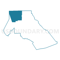
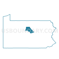
LEIDY TWP Voting District, Clinton County, Pennsylvania
About
Outline

Summary
| Unique Area Identifier | 658639 |
| Name | LEIDY TWP Voting District |
| County | Clinton County |
| State | Pennsylvania |
| Area (square miles) | 97.15 |
| Land Area (square miles) | 96.54 |
| Water Area (square miles) | 0.61 |
| % of Land Area | 99.38 |
| % of Water Area | 0.62 |
| Latitude of the Internal Point | 41.40413660 |
| Longtitude of the Internal Point | -77.86042200 |
Maps

Graphs
Select a template below for downloading or customizing gragh for LEIDY TWP Voting District, Clinton County, Pennsylvania


Neighbors
Neighoring Voting District (by Name) Neighboring Voting District on the Map
- CHAPMAN TWP Voting District, Clinton County, PA
- EAST KEATING TWP Voting District, Clinton County, PA
- EULALIA TWP VTD EAST FORK, Potter County, PA
- GROVE TWP Voting District, Cameron County, PA
- NOYES TWP Voting District, Clinton County, PA
- STEWARDSON TWP Voting District, Potter County, PA
- WHARTON TWP Voting District, Potter County, PA
Top 10 Neighboring County Subdivision (by Population) Neighboring County Subdivision on the Map
- Chapman township, Clinton County, PA (848)
- Noyes township, Clinton County, PA (357)
- Grove township, Cameron County, PA (183)
- Leidy township, Clinton County, PA (180)
- Wharton township, Potter County, PA (99)
- Stewardson township, Potter County, PA (74)
- East Keating township, Clinton County, PA (11)
Top 10 Neighboring Unified School District (by Population) Neighboring Unified School District on the Map
- Keystone Central School District, PA (37,799)
- Cameron County School District, PA (5,085)
- Austin Area School District, PA (1,278)
Top 10 Neighboring State Legislative District Lower Chamber (by Population) Neighboring State Legislative District Lower Chamber on the Map
Top 10 Neighboring State Legislative District Upper Chamber (by Population) Neighboring State Legislative District Upper Chamber on the Map
Top 10 Neighboring 111th Congressional District (by Population) Neighboring 111th Congressional District on the Map
Top 10 Neighboring Census Tract (by Population) Neighboring Census Tract on the Map
- Census Tract 9504, Potter County, PA (3,100)
- Census Tract 301, Clinton County, PA (3,092)
- Census Tract 9602, Cameron County, PA (3,012)
- Census Tract 9505, Potter County, PA (2,182)